D&D Edition Compatibility
The lore of the Forgotten Realms has evolved across its rich history in different D&D editions. This page explains the methodology Toril GIS uses to effectively synthesize information from all canonical sources. It details how data from various eras is integrated to create a single, cohesive, and comprehensive cartographic resource for the setting.
The 2nd Edition Basemap
Our approach is anchored in the 2nd Edition Advanced Dungeons & Dragons era. This period produced the most comprehensive global cartography for the setting: the beautifully illustrated Forgotten Realms Atlas (FRA) and the more complete Forgotten Realms Interactive Atlas (FRIA). Since the printed Atlas is essentially a subset of the digital FRIA, we use FRIA as the project’s primary foundational reference. Its cartography is then carefully georeferenced into our custom Toril Coordinate System to create the Toril GIS baseline. As a result, we have a stable and globally consistent world map upon which all other details are built.
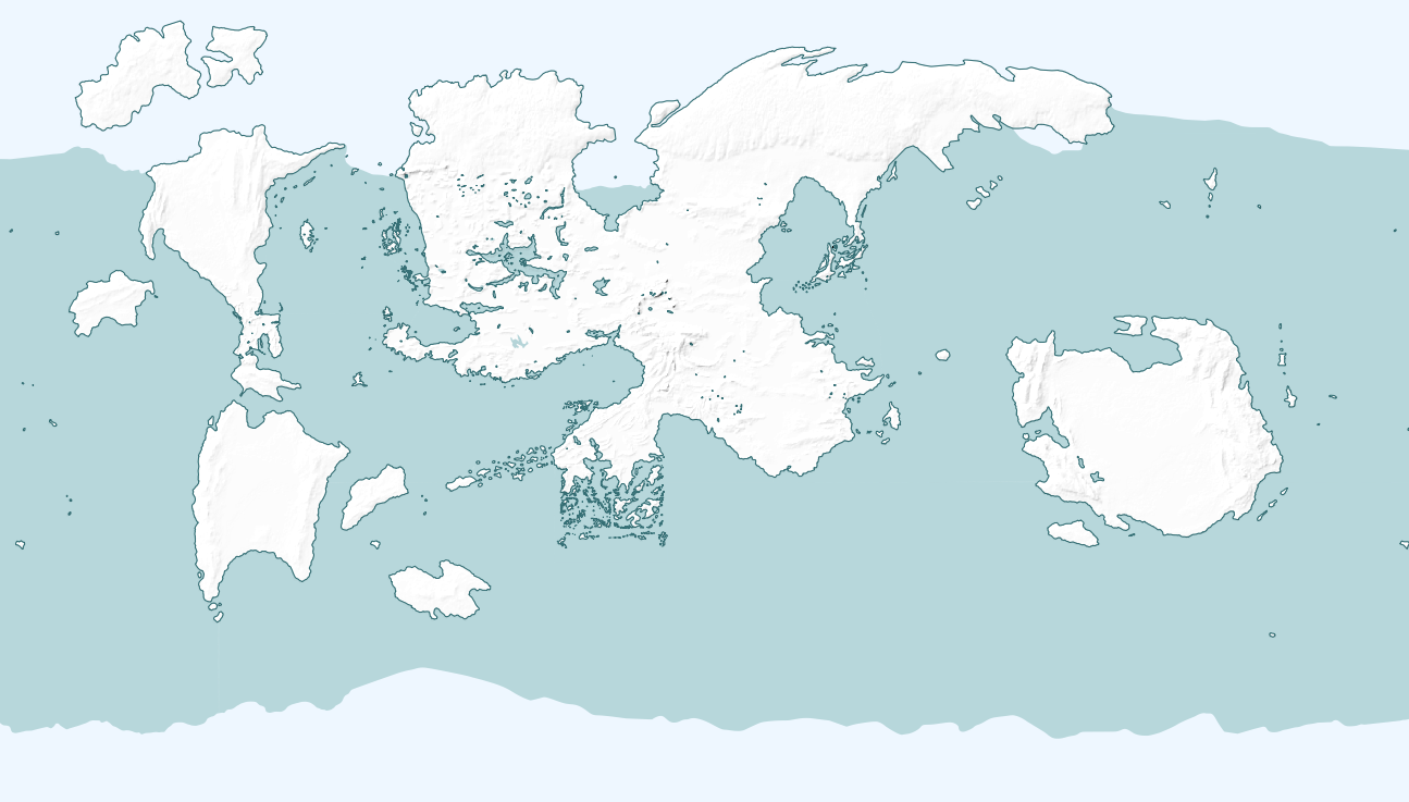
The continental outlines of Toril, based on the 2e FRIA cartography.
Integrating Other Editions
While the foundation is from 2nd Edition, the goal is to create a resource that is useful for all eras of play. Here is how content from other editions is handled.
3rd Edition
A significant challenge of this era is that the canonical WotC Faerûn map does not align perfectly with our 2nd Edition FRIA basemap when directly overlaid. To solve this, the 3rd Edition map underwent a specific digital alignment process. In QGIS, we identified over 900 matching control points on both the 2e and 3e maps and applied a Thin Plate Spline transformation. This technique non-uniformly warped the 3rd Edition map—stretching it in some areas and compressing it in others—until it fit the 2nd Edition framework. This process, known as georeferencing, now allows any map derived from that master 3e source (like the Underdark or Political maps) to be accurately integrated into Toril GIS.
 Warping the 3rd Edition map to align with the 2nd Edition basemap, which introduces necessary distortions for a good fit.
 Applying the same transformation to the 3e Underdark map.
4th Edition (Spellplague)
The cataclysmic Spellplague didn’t just alter the lore; it created a version of Faerûn that is, cartographically speaking, a completely different world. We attempted to georeference the canonical 4th Edition map to our 2nd Edition basemap, but the geography is so radically different that a meaningful alignment is impossible—the 4th Edition map is simply alien to the project’s framework.
5th Edition (Post-Sundering)
The events of the Sundering largely restored Toril’s geography to its pre-Spellplague state, making 5th Edition source material (e.g., 2015 Sword Coast Map) highly compatible with our 2nd Edition basemap.
 Georeferencing the 5th Edition Sword Coast map on Toril GIS. Note the minimal distortions needed for alignment, especially when compared to the 3e map.
Guiding Principles
In summary, our methodology for edition compatibility follows these core principles:
- The 2nd Edition geography from FRIA serves as the definitive basemap for the world.
- Content from other compatible editions (3e and 5e) is used to add detail and enrich the baseline, not to overwrite it.
- Cartography from the 4th Edition is not used as a source for this project.
- The
sourceattribute for every map feature clearly indicates the specific publication and edition it was derived from. - To make this compatibility practical, every feature has a
dnd_editionsattribute. This is an array (e.g.,['3e', '5e']) that lists the editions in which the feature is considered present. This allows you to use filters in QGIS to visualize the map as it appeared in a specific edition, showing or hiding features accordingly.